Settlement Areas
- Township Map Showing Historic Settlements
- Sponsorship List from 2001 Sesquicentennial Sign Project
- Mulmur Sesquicentennial Settlement Binder
Settlement Area Signage & History (in alphabetical order)
Airlie
Since 1863
Once known as "Mill Hill."
In the 1870s and 1880s, three sawmills were in operation. By 1890, the population had grown to approximately 100 people. The settlement had two stores, a hotel, and two blacksmith shops. Early settlers included the Dickey, Bradley, and Hare families.
Airlie was located on the extreme eastern side of the township, at the corner of County Road 21 and the Mulmur/Tosorontio Townline. It was situated on a branch of the north division of the Grand Trunk Railway and was once known as "Bonny Town."
The post office opened on July 1, 1869, with George B. Lee as the first postmaster. Pioneers who cleared the land in the early days included the Kidd, Morris, Dickey, Bradley, Pangman, Jones, and Hare families, many of whom were of Irish descent.
According to a letter from Mark Little of Toronto in 1977, his great-grandfather immigrated to the Banda (Avening) area in the 1830s. He was a mill manager for Mr. J.B. Smith. Mark's father was born in a log cabin on the 7th Line of Mulmur. At one time, he owned a mill in Terra Nova and Lisle. Mark himself was born in Lisle, where his family also owned a general store.
In the 1870s and 1880s, several sawmills were in operation, including Parkhill Mill on the west side of the creek and Henry's Mill on the east side. J.B. Smith and Mr. Zimmerman also operated mills. Over time, the community grew to include a hotel, two stores, two blacksmith shops, and twelve houses.
By 1890, the population was approximately 100, and the postmaster was Richard Bradley. Mail was delivered daily.
The town's blacksmiths were James E. Lennox and A. Parsons. The Canadian Express Agent was John Woodruff. The hotel keepers were Henry Cherry and Louis Ward.
Elijah Kidd was a prominent citizen of Airlie. He was elected Deputy Reeve of his native township three times and served as Reeve for one year in 1916.
Banda
Since 1845
Early settlers: Latimer, Clemenger, and Thomas. By 1860, Banda had grown into a thriving community of 50 people, featuring a hotel, blacksmith, post office, stores, wagon shop, shoemaker, school, Orange Lodge, and two churches. The site was well known for its cattle fairs.
Banda is located at the corner of the Mulmur/Nottawasaga Townline and the 6th Line, east of Hurontario Street. The name was chosen by the first postmaster, John Clemenger, from a map of the East Indies, where the Banda Islands and Banda Sea are located.
A Mr. Little arrived in the Banda (Avening) area in the 1830s and worked at the mill in Airlie for Mr. J.B. Smith.
In the spring of 1845, Mr. John Lott settled on Lot 2, Concession 4, along with his grandfather, Duff. The Willcox, Beatty, and Clemenger families arrived soon after.
A log school was erected in the 1850s, and S.S. #6 was built in 1857.
John Clemenger settled on Lot 32 in 1851 and was appointed postmaster in 1860. By 1864, the population had reached 50, and James Bruce was the schoolteacher.
By 1869, the community had attracted many tradespeople, including:
- Neil Bain – Carpenter
- John Clemenger – Wagonmaker
- Thomas Cloughley – Blacksmith
- Robert Flack – Farmer
- Henry Graham – Merchant
- Joseph Hood – Merchant
- William Lattimer – Farmer
- William Little – Cabinetmaker
- Hugh Munro – Carpenter
- John Perry – Carpenter
- John Thomas – Farmer
- George Walker – Farmer
Christ Church, Banda, was built in 1865. By 1890, the community had Presbyterian, Methodist, and Episcopal churches.
Orange Lodge #426 was organized around 1870, and a hall was erected. It served a large area and had 60 members by the 1880s.
J.D. Carveth was the postmaster in 1890, and the community enjoyed daily mail service, as well as a daily stagecoach to Glencairn for a fare of 25 cents.
By this time, Banda was home to many families, including:
- Beatty
- Bell
- Campbell
- Carveth
- Clark
- Clemenger
- Daniels
- Duff
- Gowan
- Hortopp
- Lindsay
- Millsop
- Montgomery
- Morrow
- Potter
- Richmond
- Sheppard
- Stewart
- Tracey
- Wilcox
An agricultural fair was held in Banda as early as the 1860s.
Blackbank
Since 1842
Early settlers: William Rusk, Henry Allen & Wm. McClinton who provided land for a grist mill. By 1890 there was a general store, post office and Presbyterian Church. A well-known site for annual strawberry festivals.
Black Bank is situated on the 25th Sideroad between Con. # 1 and Centre Road. It was first called Britannia but when an application for a post office was submitted, they found the name Britannia was already taken. It, consequently, derived its name as the result of a practical joke. Mr. Henry Allen enlisted the help of his friends in Banda to secure a post office for the area. His friends knowing that Mr. Allen did not care for a spot in Ireland called Black Bank filled in this name on the application. It could not be changed later and stands to this day.
In 1866, William McClinton purchased lot 26, Conc. #1. In 1876, he sold a mill site to Mary Plewes and Mr. Tarbush with the privilege to build a dam across "Dufferin Creek. The flour mill was built and run by James Plewes, Tom Turrell, George Smeal and T. Wallace until the '80's when it burnt down. This was the era of greatest prosperity for Black Bank.
Henry Allen was the first Postmaster followed by John Newell. Mr. Heitman, of Collingwood, built a general store next to the mill.
Some other residents in the 1870’s were: Allan, Andrews, Bates, Beatty, Craig, Dinsmore, Dunseath, Gallagher, Hogen, Johnston, Levin, Molington, Moody, Nelly, Nelson, Newell, Orr, Perry, Purdy, Quinn, Radford, Rusk, Stewart, Wilson.
By 1890, there was a Presbyterian Church and a school. Henry Heitman was the Postmaster. By then Bellamy, Dick, Hogg, Jemmison, Moffatt, Paughbam, Rinn, Scriver, Shaw and Thirston had joined the community.
Black Bank's close proximity to Ruskiew, which was further east around the 2nd line, linked the two communities in many activities.
Boyne Mill
Since 1866
Built by Edward McMulkin to grind local wheat into flour.
In 1893 John Plewes changed it to a chopping mill for animal feed. The Sawyers family, James and his son Harry, operated it from 1919 to 1968.
It is now a private residence.
The mill was located on the sixth line of Mulmur (now known as Airport Road) where it crosses the Boyne River. The first Irish settlement formed an attachment for the Boyne because it reminded them of the Boyne back in Ireland and also because water was a source of power.
One of the first needs of the settler in the 1800's was flour. To alleviate the necessity to travel many miles to the Sheldon Mill, Mr. Edward Mc Mulkin had the grist mill built around 1866, by John Sindalls, carpenter. In 1867, the mill was purchased by Mr. David Gemlo. He was listed in the 1881 Atlas of Canada as a miller, a farmer and the postmaster at Stanton. He owned 235 acres of land. 1876, Dalton McCarthy, M.P. for South Simcoe purchased the site but never lived there. It had a succession of tenant millers.
The mill had three mill stones in use. One of the tenants, Dixon by name, installed rollers for making flour but this proved to be unsuccessful, and the stones were again in use the next year.
During the years from 1876 to 1893 the mill fell into disrepair. Large mills were beginning to take over and the small ones gradually closed.
Boyne Mill was spared when purchased by Mr. John Plewes in 1893. He was a hardworking and progressive man becoming a very popular citizen of the community. Mr. Plews was a beekeeper and bred poultry as a hobby. John Plews and his three sons renovated the mill, built a new flume, cleared out the raceway and the old mill gained a new lease on life. Originally from Kimberley in Grey County he returned there in 1903 to spend his training years.
The mill, in 1903, then passed into the ownership of Mr. Thomas Sterling, who was the miller at Shepherd's Mill at Primrose.
Due to the ill health of the Sterlings, Boyne Mill was sold to James Sawyers, a native son of Mulmur township, in November 1920. An oat roller was installed, and the open flume replaced by a barrel flume.
In 1940 James Sawyers turned the mill over to his son Harry. In 1945 the spring floods washed away the dam completely. Harry replaced the dam with a modern cement one. In the 1940's, storage bins and extra elevators were installed.
The mill is currently maintained as a private residence with beautiful gardens and a wonderful landscaped woodland setting.
Earnscliffe
Since 1850
First settler, George Rutledge. By 1870 it was a small hamlet with a log schoolhouse. A post office existed from 1891 through to 1915.
Earnscliffe was located on the 4th line of Mulmur, lot# 4, concession 4. Unlike most of the communities in Mulmur it did not possess a mill. It would appear to have been a farming community. Stories tell that it was named after the new residence of Sir John A. Macdonald in Ottawa (Eagles' Cliff).
History records that Macdonald changed the name of his home from Reynold's House to Earnscliffe in 1883. One is left to wonder which had its name first the Mulmur settlement or the Ottawa house.
S.S. #16, a log school, was built on lot #5. It was replaced by a second school in 1873 to accommodate the growing families in the area.
Mr. Land was the first teacher with 60 or more pupils. The school closed for a period of five years and then reopened. The exact date is not known but the school was moved to concession # 3, one road to the west where it existed until 1954.
The records show the following were teachers at S.S.# 16: Ed Halbert, Edna Halbert, Eleanor Guthrie, Donna Betcheson, Tom Allison, Grace Krauter, Mrs. A. Myers, Mrs. Bessie McCutcheon, Margaret Bailey, Barbara Lougheed, Barbara Gallaugher and Yvonne Beaton.
Earnscliffe did, however, become a post office in 1891 with Mrs. Eliza Robinson as its first postmistress. This office closed in September 1914 but the school remained.
The 1872-7l Directory lists residents as A. Bradley, Richard Bradley, John Fletcher, William McElroy and George Rutledge. The Farmer's Directory, 1894, showed that the population bad grown to include: The Bradley’s, John Fletcher, Thomas Armstrong, James Creary, Thomas Dudgeon, Benjamin Hill, E.G. Hill, Thomas Irwin, Alex Johnston, R. McMaster, G. Moore, Nixon Rutledge, Walter Tbisde and Richard Weir. The Rutledge farm stayed in the family for over 100 years.
Halls Corners
Since 1842
Settled by William 'English' Hall. He soon owned all four corners of the adjacent townships, and by 1850, a coaching inn on the Toronto-Sydenham Road.
The corners referred to were at the junction of the four townships, Mulmur, Mono, Amaranth and Melancthon.
The original parcel of 200 acres on lot 32 in Mono/Amaranth was obtained by William "English” Hall, under a United Empire Loyalist grant. William had emigrated to Canada in 1830 from his native land of England.
Mr. Hall erected a log building for himself and provided enough space for passing travelers. This advantageous spot was located on the original Toronto-Sydenham Road.
William became renowned for his story telling good humor and the pro-rider of excellent lodgings. He quickly expanded and acquired more than l,000 acres, thus becoming a property owner of all four corners in the four townships. (The current position of Highway # 89 leaves a small portion of Mulmur Township on the south side of the highway). A brick home was built for his wife and nine children. The Hall tavern became known as the Coaching Inn when a barn was built to house the horses of the stagecoach on their journey from Toronto to Owen Sound. The stone foundation is still visible as is the well, now covered over.
William Hall died in 1883. The property was purchased later by Dr. and Mrs. W. Goodman. The barn and implement shed were still standing. Much care and love has been put into the repairs and restoration. A photo of the house enabled the Goodman’s to reproduce much of the gingerbread trim and original details. The shed has been converted into a workshop for the space and tools of Dr. Goodman's hobby of woodworking.
The vast acres are now devoted to the growing of many special species of trees. The current name of the property, Vanaheim is derived from Nordic mythology, meaning four winds. Given Dr. Goodman's parents' emigration to Canada from Iceland in 1890 and the strong winds Dufferin County is noted for, a very appropriate name.
Happy Valley
Circa 1875
A short lived lumber settlement. Campbell and Wilson operated a saw and shingle mill run by steam. Nine families lived in log houses.
This hamlet grew around the clearing of the land for three lumber mills. The Campbell and Wilson Mill was at the foot of the 6th line, immediately north of the Pine River, on the 17th Sideroad around 1870.
Two other mills in the area, The Harrison and Hatton Mill, just west near the 5th Line (Happy Hollow), Henry Mill (about 1873) to the north of the 20th Sideroad (Rookery Creek).
The property of the Campbell Wilson Mill was later owned by Hugh Lamb. Nine log houses were built for the workers. Each had a cow or two, a few pigs, hens and sheep. Mr. Lamb grew feed for the animals, and they had their wheat ground at the Boyne Mill to the south. Mr. Lamb was a man of many talents. He could weave carpets, flannel and other cloths.
The Lambs had three sons James, George and Archie. Other workers were Mr. & Mrs. Bill Sloan (Mrs. Sloan kept a boarding house), Dick Atkinson, Bill Frockins, Jim Duffin, Archie MacIntyre, Pokelong and Ivon Symington. A shingle mill soon joined the lumber operation.
About 1888 the best of the timber had been logged and the Campbell-Wilson partnership was dissolved. Campbell moved to Cookstown but built a large home in Happy Valley. He became quite prominent in municipal government and served the township as a Councillor and a Deputy Reeve from 1879-1881. These were the beginning years for Dufferin County.
Mr. Wilson moved to lot # 21 and continued farming.
The Lamb family, among the early pioneers, played a very important part in the milling business and remained in the area. HAPPY HOLLOW, nearby, was the site of the Hatton Mill, which later was the John Sawyer farm. Bill and John Hatton were joint owners with Wilmot Harrison. They employed 28 men who lived at Mrs. MacDonald's boarding house. Mr. MacDonald was the foreman at the mill. This mill has often been referred to as MacDonald's Mill or Sawyer's Mill.
Honeywood
Since 1848
First settler: Elijah Broderick.
Called 'Yorkshire Settlement' for the pioneers who left Yorkshire England. The hamlet became a prosperous village with 2 stores, 2 churches and 3 banks. Pioneer descendants still farm here.
This village is located in the northwestern corner of the township, on the 2nd line west of Hurontario Street, on lots 25 and 26 and the 25th sideroad of Mulmur.
The name Rosewood was chosen by Mr. Wood of Toronto who had received a large tract of land for military scenic rendered. His wife's name was Rose and then his own surname. It was discovered that this name had already been taken and so he substituted Honey for Rose, Honeywood.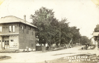
It was a heavy wooded area with rich farm land but was ignored because of the hazards of frost. In 1842 Elijah Broderick secured land from the crown on the southeast corner of lot 25. At this time the area was in Simcoe County. Dufferin County didn't exist until 1875. In 1848, many from Yorkshire, England sailed to Canada. Among those was John Foster who settled m Ped but two of his sons Ralph and William journeyed further to secure lands in this area. Others who followed included Robert Grey, George Siddall, Robert Mortimer with sons Manuel and Mark, John Corby, James Wilson, Rueben Storey, George Anderson, R. Bell and Ben Lister. In the early 1850's Jonathan Copeland, Jerry Lamper, Abraham Ralph Foster, Thomas Hunt and William Brooks all settled in the area. Acres of bush were cleared to make way for the agricultural section that followed.
The early years saw settlers travel to Horning’s Mills to the south for their mail. In 1865 the village of Honeywood received its own Post Office and Dr. Robert Lawrence was its first Postmaster. At this time a hotel was built by Joseph Broderick, son of Elijah and a small store was operated by William Noble.
George and Theodore Lawrence came from Lavender and purchased the Noble store. Their brother Dr. Robert Lawrence opened a medical office and a chemist shop in the store.
Attention was then directed to a cemetery for all creeds and colours and the building of a log school. In 1855, The Public School Act deemed it necessary to build a log school on the south west corner of the cemetery where it stood for many years, with the stipulation that it could be used by the clergy of every denomination as a meeting place.
In 1870, the Methodists built a frame church which was replac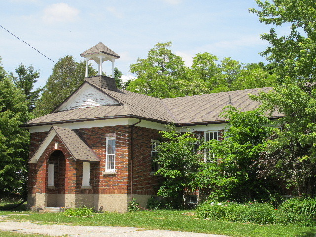 ed in 1901 by a brick building and is now used by the United Church. The Anglicans followed in 1884 with a brick church.
By 1871, a new school was built on the Prince of Wales Road. This was soon too small, and a brick school was built-in 1883 on the sideroad one-half mile east of Honeywood. Several years later another school was built on the Upper Sideroad, and the Prince of Wales Road building was closed. The first teacher in the old log building was Angus Bell. He was followed by Robert Reid in the brick school'
The village is now a thriving place and residents were served by Mr. Bowers, Mr. Ripley and Mr. McConachie at the general store. William McCracken, tailor, W.J. Finley, shoe repairs, blacksmith Mr. Joseph Tupling, a plaining mill run by the Siddall Company joined the businesses of Honeywood
In 1873, eight hotel licenses were granted: W. Gilbert, T.E. Bates, J. Brown, E. Henderson, W.A. Beaty, J. Sullivan, R. McCracken. ·
The community of Honeywood has many families that trace their history back to the early days of the area; Broderick, Copeland, Foster, Siddall and Tupling, just to name a few. Community spirit is alive and flourishing today in this friendly village.
Kilgorie
Since 1859
Early settlers: Lloyd, Gallaugher, & Maw. By 1885 it was the site of a post office, two saw mills and a school known as 'Old Egypt'.
A power plant was built in 1909 by Huxtable's Dufferin Light & Power Co.
Kilgorie was settled at the junction of the Centre Road (Hurontario Street) and the 15th sideroad of Mulmur Township on the Pine River.
William Clark Street had a crown deed for 2 hundred acres, lot 17, concession 1 E.H.S. in November 1859 but was not a permanent resident it appears.
The Lloyd Family made their way from the King District of Ontario to develop this area. James came in 1863 and built a log house on part of lot 19. This building still stands.
Benjamin and his wife arrived in 1867 followed by William in 1868.
At this time Kilgorie was named after an Irish town as a joke on the settlers who were mostly English and Scottish.
Newton Maw acquired the west half of lot 19 in 1872 and later in 1881 became the first Postmaster. His widow followed in that position and then Joseph Gallagher, Mary Lloyd and Thomas Dorsey until the post office closed in 1914. Other settlers at the mine were Hoare Frees, Thomas Dorsey, Justice of the Peace and John Allen.
A road was surveyed from Terra Nova to Whitfield by Mr. McNabb. Later the road known as River Road was surveyed to Horning's Mills.
1859 brought Thomas Huxtable who acquired the river rights and the adjoining land of lot 15 from H. Free. He built a dam and power plant which for a while supplied Horning's Mills.
At first students had to attend Beach Valley School or Whitfield but in 1875 the settlers wanted their own school, and one was built as a supplementary school to Whitfield on lot 16, south east corner and the 15th Sideroad deviation. Rules at the tine stipulated that each pupil had to have so many square feet in the schoolyard.
Mr. Stewart was the teacher and Robert Gordon the Inspector. These gentlemen quarreled so often during the years that England and Egypt were at war that the pupils promoted them to generals and the school was nicknamed "Old Egypt". In 1908 plans were underway for their own school division and a new school, S.S. # 15, was built on the south east corner of lot 16 east of Prince of Wales Road. Money was borrowed from Mrs. Ben Lloyd to finance this project. The enrollment was 29 pupils.
The School Board was H. Free, Ben Lloyd and W. J. Wrigglesworth. Mr. W. J Dorsey was the Secretary, Miss Neville, the teacher and Bill Exelby, the janitor.
By 1890, Kilgorie's population was 60, they enjoyed tri-weekly mail and boasted of 2 churches, Episcopalian and Methodist, a common school, 2 saw mills and shingle mills.
Business owners were: Thomas Dorsey, J. S, Gallagher, John Laskin, J. H. Lloyd and John Scriber.
One of the oldest farms on lot 28, Centre Road has been in the Lloyd family for over 100 years and is currently owned by a great-grandson of the original owner.
Lavender
Since 1837
Originally called Masten's Corners, Lavender grew to include a hotel, stores, post office, blacksmith shop, cheese factory, Temperance lodge and two churches. Only five houses and a church remain.
This agricultural community was located on the Mulmur Nottawasaga Townline at the juncture with the Centre Road. Many think the name originated from Lavender Hill, Battersea, London, England. Others credit the name to the abundance of sweet-smelling flowers in the area.
Israel Masten opened a hotel on the Mulmur side in 1837. Part of this building still serves as a farmhouse for the Davidson family.
The first Post Office, in 1860, was called Masten's Corners with Mr. Masten as the first Postmaster as he was the owner of the first team of horses in the area. Benjamin Heaslip succeeded him. The name Lavender was adopted in the same year. At this time the community consisted of a hotel, stores, Post Office, blacksmith shop, the Sons of Temperance Lodge Hall, 2 churches and a cheese factory. Local farmers provided the: milk. In 1862, the Dickson and Flack cheese factory was in operation, another blacksmith, a veterinary surgeon, named Robert Lackey, and carpent.er George Anderson were part of the settlement.
By 1864 the population was listed at 30 and grew to 120 by 1871. Names on the register included William Anderson, Isaac Allen, James Coe, John Crawford, Oliver Decker, John Dixon, James Ferris, Rev. Thomas Foster, James Galbraith, James Givens, William. Hair, Robert Hamilton, John Hawkins, George Hodgkinson, Richard Hutchison, William Johnston, Robert Kirby, George Lawrence, Richard Long, Peter McHaffie, John McNichol, Israel Bowerman Masten, Lewis Masten, Peter Masten, Edward Matchet, Thomas Milsap, Robert Noble, John Pratt, Rev. Richard Redeoff, Joseph Scot, James Shaw, Samuel Walden, George Weatherall, James Weatherall, Joseph Weatherall, William Weatherall, William Wilkinson, James Willson. Five farms in the community still remain in the same family: Anderson, Brett, Hawkins, Johnston and Martin.
The Methodist Church still remains along with the cemetery.
Mansfield
Since 1830
Earliest settlers: Harper Beazer Colquohoun, Cauthers and Love. By the 1850'd a log church, school post office, store, hotel, shoemaker, blacksmith, saw mill, flour & woolen mills, carriage & carpentry shops thrived.
Mansfield is located at the junction of the 6th line (Airport Road) and the 10th Sideroad. It is generally thought that the name was coined because of the manse in the field on the glebe. Settlers arrived in the area about 1837 and the first resident was Jack Harper, who built his home on the north-east corner.
By 1871 the population had grown to over 100. Some of the names on the records of that time were: Abraham, Anderson, Armstrong, Arnold, Black, Brett, Campbell, Colquhoun, Cook, Cowan, Gallagher, Gilbert, Grier, Holdship, Lee, Leggatt, McCracken, McMahon, McMulkin, Morrow, Noble, Silks, Smith, Stinson, Symington, Upton, Wilson, White and Wren.
A log church was built in 1844, a glebe of 100 acres was purchased (east half of lot l 0, on. 6). This was served by an itinerant Presbyterian missionary named Alexander Lewis. In 1853, the manse was built, and Rev Archibald Colquhoun was the minister. By 1869 a frame building replaced the log church. The· earliest marker in the cemetery is 1855 but there are many unmarked graves from 1844 to 1855.
Shortly after Jack Harper settled in, Mr. Cornelius Beazer built a hotel and general store on the same corner and later sold to William Gilbert. Beazer then built a second more pretentious hotel a little further north to serve the travelers going to Bradford or Toronto. It closed and was torn down and the site is now the Anderson residence.
William Gilbert operated the hotel and general store until his death and the business survived under the ownership of his widow who had married William Cotton. Upon his death, the hotel closed but was opened as a general store by Jack Dick. Five months later it burned down.
The first Post Office opened in 1858, on the site of Harper's house and Beazer's hotel. Upon William Gilbert's death, the general store, founded by Beazer and Gilbert, was taken over by his son in-law, Malcolm Colquhoun and then by Hezekiah Gilbert, a son of William. The store followed the Post Office to M. Colquhoun house and with Hezekiah Gilbert, from there to the north-west Corner its present day location. A second store was built further north across &om the new Beazer hotel by John Black. Subsequent owners were William Gallaugher and James Reid. This store also suffered a fire and closed.
The first school in the area, circa 1860's, was a log building, JS ft X 40 ft, on the 5th line just north of the 10th sideroad. The teacher was William Kiernan. Pupils sat at 2 rows of desks.
The enrollment in winter was reported to be about 78 students. This school, built before the settlement was a village, closed in 1872.
The community continued to flourish and soon attracted an apiarist, David Anderson, a flour mill, David Armstrong, carpenter, John Lee, a woolen mill, owned by Joseph Upton & W.H. Wilson, hotel owner, George Cook, shoemaker, Charles Weir, etc. Avon Symington opened a carpentry shop and built many barns and houses in the area as well as the former Perm and Mount Pleasant Methodist Churches. Mr. Howard Thatcher's business sign read; Howard Thatcher and Company, painters, glaziers, paper hangers and shoemakers.
A man of many talents. This passed to Irwin Armstrong and in 1903 to William Cauther. He built a new shop at the east end of the village. Robert Campbell was the first blacksmith, originally located at the north-west Corner by later moved to the south west Corner. This shop continued to opera under John Law, Thomas Long and finally David Long until closing in the 19S0's.
John Abraham was a butcher, harness maker and singing master. 1888, he moved from Alliston to Mansfield and held very popular singing classes at Rosemont, Stanton and Mount Pleasant Church.
Mr. Mathers set up a tailoring business at the 10th sideroad and the 5th line. He traveled to homes and used homespun material woven by the pioneer women. Mr. Munson was a journeyman tailor and travelled on foot, carrying his supplies. He was a notable fisherman and loved the outdoors. His specialty was making double-breasted vests with a rolled collar. There are many photographs to illustrate his design.
Mansfield, then as today, was a sporting community. In 1870, they held a Dominion Day football and baseball game against neighbouring Stanton. Ben Leggatt was the football coach won this game. The baseball team (some names: Mansfield, Sam Noble, Stewart Noble, Archie Noble, Robert Gallaugher; Stanton, Wynn Hand, William Hand, Thomas Bates, Thomas Campaign) were defeated by Stanton and had to pay for their supper.
Dominion Day tournaments became a family community tradition and continued into the 1990's.
Some of the original families who cleared land and are still in the area and are proud to trace their roots back to those early pioneers: Hodgson, Stinson, Gallaugher, Colquhoun, McKee, Cook and Jamieson.
Mulmur Corners
Since 1824
Oldest settlement in Mulmur.
1st settler: John Little. Post Office established in 1841. By 1860 a population of 40 included a blacksmith, shoemaker, harness maker, stores, hotel, courthouse, an Anglican church and school.
This heritage community was located at the junction of highway # 89 and the 7th lines of Mono/Mulmur townships. The name is believed to have been given by the surveyors.
Mulmur was thought to be a coworker of Martin Luther.
The first settler was Captain John Little around 1824. He brought his family north to settle on Lot 1, 7th concession, a property of some 100 acres.
Because his family had to walk to Mono Mills for church, a journey of some 15 miles, he donated land and a log church was built in 1845. An itinerant minister held services in the Little home in 1842, whenever he was in the area. This log structure was replaced in 1860 by a stone building.
 St. Luke's Cemetery, the first one in Mulmur township, is no longer active but still stands on the land of the original church. The first Post Office opened in 1841 and a store and courthouse were built on the south-east Corner. Mulmur Corners seemed to be the centre of the township business activities at this time.
In 1864, they recorded the population as 40. Names in the records included: James Aberdeen, Reeve, Murdock Bell, blacksmith, James Cumberland, harness maker, Robert Campbell, blacksmith, Mrs. Freary, Woolen Mill owner, Thomas
Gowan, carpenter, Graham Colwell, Township Clerk a Treasurer, William Hall, carpenter, John Hare, general merchant and hotel keeper, Thomas Hilock, tailor, Captain John Little, Post Master, Clerk of the Division Court Commissioner,
Alexander Mitchell, blacksmith, Hugh Morrison, Justice of the Peace, James Swanzey, Justice of the Peace, Edward Synnott, shoemaker, John Turner, shoemaker. 1869: Rev. John McCleary, Anglican, John Murphy, farmer and later Post Master and general store owner, John Neely, shoemaker, William Parsons, cabinetmaker, Art Wilkinson, teacher, W.H. Wilson, clothier.
In 1890, a two-story school was built on the south side of highway # 89, S. S. # 17. Still stands today.
Perm
First settlers were Hugh Gallaugher and family. Population: 55 by 1887. Site of 2 schools, blacksmith shop, stores, church and pioneer cemetery.
 THE ORANGE ORDER
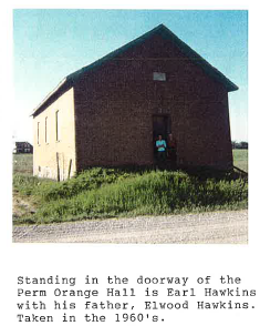
Perm Lodge No 355
Our history tells us the importance the Orange Order played in the lives of many of the first settlers who came from the North of Ireland. This enabled them to carry out the traditions of loyalty to the Crown and aggressive Protestantism.
Perm Lodge No355 received its present warrant in 1854 and it was taken out in the name of Robert Hunter. About 1910 this building was moved from its original site which was north of the farm buildings on Lot 11 W½Con.5, immediately south of the hill to the new site on the north side of Ten Sideroad, just east of the Fourth Line Mulmur. Like many Orange Halls many events were held there for example
Christmas concerts and presentations for newlyweds and farewell parties for very often the retired farmers who were moving from this community.
The exact date that this building was no longer used for the Orange Lodge is unknown. Many from the Perm area chose to be members of the Mansfield Lodge No. 784. It is believed that the Orange Lodge Building at Perm was torn down in the late 1960’s or early 1970’s.
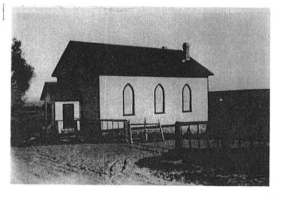 BETHEL METHODIST CHURCH PERM
THE BETHEL METHODIST CHURCH at Perm was built in 1872. The Mulmur Township History book dated 1951 writes that Hugh Gallaugher donated $500.00 to the building of this church and thereafter donated $100.00 annually towards its upkeep. This small frame church stood on the south east corner of the Perm intersection and within the Perm Cemetery grounds.
This Church was torn down following Church Union in 1925 when the congregation joined the United Church of Canada in Mansfield. The new church was built on Ten sideroad, just east of the Sixth Line, now known as Airport Road.
This early community was located at the crossroads of the 4th line, east and the 10th sideroad.
The first settlers at Perm were the Irish family of Hugh Gallaugher in 1832. This family raised 7 children: Robert, William, Phoebe, Thomas, Paul, Hughie and Hannah.
William Whitley and Robert Lee followed in 1837 and by 1887 the population had grown to SS.
Paul Gallaugher was the first storekeeper at Perm, and he also had a saw mill at Podey Mills. Paul was· succeeded by Mr. J. J. Morrow. There was a blacksmith shop operated by Joseph Donahue on the east side of the church. The Gallaugher family thrived and multiplied and spread to other farms throughout the settlement. Many of the descendants of these pioneers are still Living and very active in the community.
Hugh Gallaugher also looked to the religious health of the area and donated $500.00 to help build the Bethel Methodist Church on the south side of the 10th sideroad. He gave much of his time and energy to the project. When the church was torn down in 1926 some of the materials were used to help build the new church at Mansfield and most of the members moved there.
The cemetery connected to this church is still to be found on the 10th sideroad.
The church was the focal point for the social life of the village. Choirs, Young People's groups, fowl suppers and strawberry teas, along with many sports and games were actively carried.
Perm also housed an Orange Lodge. This hall served as a community hall for meetings, entertainment, and dances. Lively debates were held by opposing candidates for political office.
Perm's citizens were well represented on the Township council The farms grew in numbers with the coming of the John Ireland, William Kirkpatrick and William Ferris families.
Perm claimed two school sections: Upper Perm (S. S. # 8) and Lower Perm (S. S. # 21). Upper Perm was built about 1860 on the 3rd line. This was a 20' x 30' structure with benches. The first teacher was Mr. Black followed by Mr. Burton. In October 1935 this building burnt down and was replaced with a modern brick school. It was slightly west of the original site. This was a good brick structure and is still in use.
Lower Perm "as located on Lot 11 on the l 0th Sideroad. It began as a log building in 1872 and was united with S.S. # 8 until 1917. It still stands and today is a private residence. The children of the new world were not great writers because using a slate is a very awkward way to learn writing. Also, they learned to read by word/object association. The "Phonic Method" and "Word Method" were not in use just yet. Their text books contained many fine pieces of poetry and prose.
Ponton Mills
Circa 1870
A dam & grist mill was established here in 1869 by George H Shepherd.
It operated until the early 1900's.
Ponton Mills was not in the true sense of the word a settlement but was an important location due to the establishment of a mill there by George H. Shepherd in 1869.
The location was strategic to travel as it lay just to the north of the junction of the Mono/Mulmur Townline (Highway# 89) and concession # 1, West (Prince of Wales Road). It was on the west half of lot 2.
This mill continued to be operated by Mr. Shepherd until almost the turn of the century.
Relatives of this pioneer are still to be found in the Ponton Mills area.
Primrose
Since 1850
Early settlers: De Graham, Dodds, Henderson & McCutcheon. By 1870, an important settlement on Prince of Wales Road with hotel, post office, school, flour mill, stores and two churches.
Site of early cattle fairs.
Primrose grew rapidly because of its prime location at the junction of what is now Highway # 89 & # 10, Mono/Mulmur Townline and Concession# 1, west of Mulmur. The name appears to have been derived &om the flowers that grew on Primrose and in London.
An early settler was Colwell Graham, an Irishman, who arrived about 1850, cleared the land and built a home for his family. They eventually grew to number 8, 5 sons and 3 daughters.
In 1860, the Prince of Wales Road was completed from Orangeville to Primrose. In due course the Post Of6ce was opened by C. McCutcheon in 1860 on October the 1st. This brought a little general store which was welcomed by the settlers. This was run by George Dean who had arrived in Primrose in 1858. The long trip to Mono Centre for supplies was no longer necessary.
James Dodds arrived and built a &ne new store and took over the duties of the Postmaster. The Dodds raised a family of seven, 4 sons and 3 daughters. James soon became a Justice of the Peace and was reputed to be a &ne Conveyancer. The family were all devoted members of the Whitfield Presbyterian Church. 1869 brought the Ponton Mill to the banks of the Upper Boyne River just north of Primrose. Mr. George Shepherd undertook the task of moving his mill through the bush from Homing's Mills to its southern location.
The 'village population grew to about 350 by 1871.
Mr. Edward (Ned) Henderson obtained a license for his new hotel, The Prince of Wales Hotel, in 1873 and continued to operate it until 1880 when it passed to George Dean. A new hotel was built in 1886 and survived until the 19801s as a lodging and eating place.
Primrose hosted a monthly cattle fair and farmers for miles around brought their livestock for sale. Buyers came from Orangeville and as far away as Brampton.
Randwick
Since 1865
Originally the site of worker's cottages for the surrounding sawmills. A post office opened in 1874 with Parkhill and Henry as first postmasters. Only the, school built in 1880 remains.
Randwick was a workers' village located at the corner of the 6th line and the 25th sideroad. This community grew because of the abundance of forests and the lumber, which were built there by Parkhill and Smith. When the pine ran out the mills moved and much of the settlement along with it.
In the late 60's, houses were built to accommodate the workers at the mills. At one time there were 32 and a small hotel. Mrs. Dickinson operated a boarding house. The abundance of trees provided free fuel for every family.
A Post Office was opened in January t874 at the request of Mr. Parkhill, and he was appointed the first Post Master. Four years later he passed the Job to William Henry. Mrs. Park, Jo.hn Bridal, John G. Jones, J.A. Creech, John Walker and lastly Mrs. Lavina Smalley held the position until the office closed in October 1915.
Mr. Parkhill served the community well and rose to be the office of Reeve of Mulmur. He served on council for many years and was in office when Dufferin County came into existence.
There was a crown deed issued to Elizabeth Markle for Lot # 29, Concession 6 in March 1835. This was then in Simcoe County. The land was not cleared but sold several times until purchased by John Pengelly. The log house he built for his family still stands and is still owned by his descendants. The Pengelly family consisted of 4 sons and 7 daughters. In 1918, young John bought the farm from his father and built a fine cement residence.
A Scottish gentleman, John Fraser arrived in 1865, from Toronto, secured 100 acres and built a shanty of green logs. He then moved his wife and family of 4 from Toronto and they arrived in December, corning from Essa by sleigh. Ten days later young David, there fifth child was born. Although they cleared the land, they found the soil was very poor. Most of the neighbours were Irish and English. Mrs. Fraser missed hearing the Gaelic language and thus walked 12 miles regularly to the East Nottawasaga Church to hear it spoken. She lived to be 84.
A school was built in 1865 but burnt down and was replaced in 1890 by a building on Lot# 24. In 1899, it was moved back to Lot# 25 by Jonathan Doner using rollers drawn by horses. The water was better and the location more central to the homes. The schoolhouse and the Post Office building still exist, one currently being used as a residence.
Randwick was not a commercial village. Banda, about l& l /2 miles away, provided the supplies, blacksmith shop and carpenters etc.
Some of the other family names familiar to the area are Carson, Grainger and Weir.
Rookery Creek
Since 1873 -1887
Site of Parkhill & Smith lumber mills, purchased by Henry brothers.
This settlement soon became a self-sustained community with many homes, a Methodist church, general store, boarding house and an Orange lodge.
The settlement of Rookery Creek grew up on the 6th line (now Airport Road) and the 20th sideroad just to the south of the community of Randwick. These were the sites of sawmills and moved to follow the availability of the pine forests.
A mill was built at Rookery Creek in 1870 by an unknown builder and was purchased in 1873 by William and Robert Henry, who operated it until 1887.
Rookery Creek boasted of two thoroughfares, Main Street and Turkey Run.
The close proximity with Randwick allowed the two communities to enjoy a self-sustained settlement, 37 homes, a Methodist Church, an Orange Hall, Mrs. Parkbill's general Store, and the Dickson’s boarding house.
W.J. Parkbill became the manager of the mill, along with the assistance of John Bridal and Alu Ferris. The mill was run by a 60 horsepower steam engine and the lumber was taken to lisle for distribution.
Prominent names at that time were Black, Collins, Atkinson, Bates, Greer, Bavair and Fleming. The blacksmith was Tom McGaw.
Rosemont
Since 1846
First settlers were Morrison and Gilmore families. By 1860, there were 2 hotels, post office, stores a blacksmith shop and 2 churches.
This community had the unique fortune to be situated at the corner where four townships met; highway # 89 and the town lines of Mulmur, Mono, Tosorontio, and Adjala. It's history is closely woven with the earlier settlement of Mulmur’s Corners, one concession to the west.
Captain John Little and his wife were the first white inhabitants of Mulmur’s Corners and thus the Rosemont area. They were joined by Hugh Morrison, The Gilmore Family, Robert Henry, George McManus, Alex Irvin, Captain Little's brother and bis wife, Robert Murphy, J. Reid, John Hoey, Thomas Irwin, Thomas Langley and William Ryan.
In 1824 The Littles came from York and settled on a crown land grant of 200 acres on the7thconcession. Part of this property is still owned and inhabited by the Little family.
Mr. Fletcher acquired 100 acres from Captain John in trade for a pair of Indian leather boots. This is not the Murphy farm.
J. Gilmore acquired land through a crown deed in 1846 and opened a store. !857 saw the opening of a general store by George Cummings in Morrison’s hotel. After his marriage, he built his own store and later sold it to E.J. Nichol. This store was two storied and featured a landing space for millinery.
There is still in operation today a general store and gift shop in Rosemont.
857 was the year Robert McDowell arrived in Rosemont area to settle land on concession # 1 Tosorontio. He was followed on this land by son Alex and his wife Norah.
At this time mail came from Gilford by stage and was then delivered north by George Cummings to Mulmur through Stanton, Mansfield and Perm and south to Mono by way of Parker Mills (later Sheldon Mills).
In 1860, Mr. Cummings was appointed Postmaster, Commissioner for Bench of Simcoe in 1866, Commissioner of Marriages in 1870, Notary Public hi 1875 and High Court Justice in 1883. Subsequent Post Masters were Thomas Hannah, Hubert Reburn, Norman Palmer, Wilibur Law, Mrs. Law, Isaac Bird Rouse (who was also a salesman and law clerk). A Methodist congregation was formed under Rev. Garner.
St. Luke's at Mulmur’s Corners built a stone church to replace the log one in 1860, under Rev. McLeary's leadership, and was debt free by 1865. In 1927 the congregation built a new brick church in the Rosemont village area on the site of the McCartee Hotel which had burnt down.
The Presbyterian congregation, started in 1839, drew Mansfield members to Rosemont to worship. This building burnt in 1901 and was rebuilt in 1902. It was sold and torn down in 1944.
The United parish built on land donated by Robert Thompson and erected a building in 1872. Peter Addison was the minister. Orange Lodge # 9 was issued a warrant in 1830 but because it was lost or burnt reissued in 1845 to Brother W. McCracken.
Meetings were held at Master W. McKee's and the membership in 1860 was between 40 and 60.
Orange Lodge # 86 was formed in 1848 by John Quigley and Brother J. Cumberland. They also met in the master's house. They built a hall in 1862.The two lodges joined together in 1922 with about 74 members and a new hall was built in 1930 using lumber &om the two older halls.
Situated as it was on the road between Alliston and Shelburne, Rosemont was a boon to travelers. A hotel had been built in 1830 by Thomas Henderson on the southwest corner of the village. The Globe Hotel's present building was built in 1859 and hosted guests until l 955. John I.aw became the hotel keeper in 1902. During this era the McCartee Hotel across the highway caught fire and stories tell that the Globe's owner's wife guarded the well on her property with a shotgun and would not allow the firefighters to save the opposition's building. This well is still in evidence today on the corner outside the current hotel. In 1968 The Needles Family, Dorothy Jane and William purchased the site. For several years it remained vacant until 1971 when the Needles began restoration work and it reopened as a restaurant in 1973. Its popularity and reputation for great food still exists today having passed through the management of the Niklaus Family to the present owners, Beth Hunt and David McCracken. Another hotel was built on the south east Corner of Mulmur township by Charles Amas in l87l, sold it to Thomas Wright. Three hotels flourish at one time: Henderson's, McCartees (burnt in l 905) and Morrisons. Two liquor stores were also open for business.
Rosemont attracted many skilled trades. John Law opened a blacksmith shop. His first one burnt but he rebuilt, and it still stands today. He was joined by John Morrison, John Brown, James Alexander James Robb. John Lackey opened a veterinary practice, Dr. Bailey moved to Rosemont from Hockley.
In the 1870's the court house at Mulmur’s Corners burnt and was rebuilt at Stanton. McBride's store also burnt and so they relocated to the Rosemont corners and reopened in Mrs. Thompson's stand (fancy jewellery). George Cummings opened
a store, Mr. McCall a tailor shop, Michael Irwin was a boot and shoe mam, Mr. Phillips operated an ashery for butter tubs, wooden pails and barrels, John Hillock ran a stage line to Shelburne and a cheese factory opened. The Cummings store was sold to Mr. Foucar, in 1904 to William McCracken and in l 907 he bought Cumberland's store.
The Village grew and prospered, consisting of l O stores, 2 blacksmith shops, a painter and decorator, carriage shop, an undertaker, veterinarian, 2 hotels, l churches with ministers and a doctor. Rosemont also became well known for its fairs and cattle shows.
Rosemont today is an active community with two churches, the Orange Hall, the busy Globe, the General Store and Gift Shop, the volunteer &re hall and boasts of a family orientated subdivision of its south east side while still being home to many old-timers.
Ruskview
Since 1848
Situated on a bluff overlooking the Pine River Valley. Joseph Lennox was the first settler to purchase crown land. By 1883, Robert Reid built a house and blacksmith shop and was appointed first postmaster.; Named for early settler Wm. Rusk.
Ruskview situated on the highest bluff overlooking the Pine River Valley commands a wonderful vista at the corner of the 2nd Line and the 25 Sideroad. The scenic location and the fact that William Rusk, was an early resident, combined to give the village its name. Un1il 1878 it was called Black Bank. Then this village moved along about 1 and a ½ miles to the west. Mail arrived in Ruskview twice a week from Honeywood, 4 miles to the west courtesy of Seymour Newell, aged 15. Seymour either walked or rode a horse.
In 1880, a store and house were built on an acre of land bought from Mr. Newell by Robert Reid. Mr. Reid wanted to improve the mail delivery and thus petitioned the government for a Post Office. This opened in 1880, Mr. Reid became the Postmaster, and the village was named Ruskview.
The store and post office were later sold to Thomas Farley. A second blacksmith shop opened near the spring, owner Robert Rina. His brother Joseph farmed in the area. Mr. Newell continued on the southwest Corner. Mrs. Rusk operated the post office for several years.
The early 18901s brought the present school and the Orange Lodge followed in 1908.
Many Rusk grandchildren settled in the area as did the children of many other early settlers. Lot # 29, Concession 4 was secured by crown deed in 1848 by Joseph Lennox. This land ownership continues into the third generation. Other prominent names in the 'Vicinity are Perry, Leven, Orr and Allen.
Scarlet Hill
Site of a post office between the years 1882 and 1889, and an Orange lodge.
Not a lot is known about Scarlet Hill. This hamlet was the location of a post office from 1882 to 1889. Opinions vary but the vicinity of the 2nd line and the 30th Sideroad appears to be the post office location.
Slabtown
Since 1880
Site of a sawmill owned by Thompson and Findley.
This settlement was primarily a lumber mill site on the deviation road leading to the 20th sideroad where it branches off from River Road about 1 mile west of Terra Nova.
The mill owners Thompson and Findlay ran a busy operation. A local resident remembers working there as a youngster and reports that there, 15 a pile of sawdust more than 30 feet high. It later caught fire and' smoldered for three years.
Another mill was built at the next creek down the road, but the life of a mill was usually short and moved as file supply of lumber depleted.
With several other established villages in the area, Slabtown did not develop as a community.
Slab Town was the name given to a small collection of 6 to 8 houses which developed around the creeks that flow into the Pine River near the junction of 20th Sideroad a d Pine River Road, Mulmur. The creeks were used by a lumber company to run their sawmills to cut lumber. The piles of slabs and sawdust left behind led to the area being called ‘Slabtown'.
According to a 'young' man; now 81, Roy Baker, there were three saws at the mills sites owned by Thompson and Findlay Company. The saws were powered by steam; the water being drawn from the creeks in the area. One man would begin building the fires to produce steam at about 5:00. a.m. so that the saws would be ready by 7:00 or so. When the distance the logs had to be hauled to the saws as too great, the mill was moved to another site closer to the source of wood. Roy Baker remembers that about 6-8 men worked on the mill site but there were many more who drew logs from the surrounding hills and farms. Roy was hired to draw logs to Slabtown as a replacement for another man who, on occasion, had 'too much of the bottle' to load his team to carry wood from the forest to the mill.
The logs once sawn into lumber, were stacked on eastside of 20th Sideroad OD the property known as 'Flintstones'. The lumber was then drawn by horse team either to the rail line near. Lisle or southwest towards Shelburne. The teams hauling towards Lisle were forced to dig into sandy roads which made the work hard, but the teamsters learned to 'shorten the load', that is, increase· the height of the pile of lumber and reduce the length; thereby reducing the strain on the horses
The road out of the Pine River Valley was more difficult because of the grade. Often, extra teams of horses bad to be hitched to the sleighs and wagons as they followed the tracks along the Pine River. Roy Baker believes some of the lumber was used to build several of the large 'round hams' near Erin, Ontario.
There were about six to eight wooden houses around the mill. They have all disappeared now. One unconfirmed report tells of a suicide at Slabtown and another, more reliable, tells of a man, having to be taken away by the county policeman because he was behaving in a very erratic manner. Another account reports that Isaac Griffith Hughson was killed by a falling tree on January 14, 1913, while working at Slabtown. (Reported by Mary Boyle)
The mill closed sometime in the late 1930's or early 1940's but, for years, the piles of woodchip’s and sawdust were local landmarks. Nawton Lloyd on River Road remembers riding bis bicycle along the road to Terra Nova past huge piles of sawdust. When the Byford/Buzzells had their pond excavated in 1990, there were still buried piles of sawdust and remnants of the mill a saw blade, several bricks and a valve.
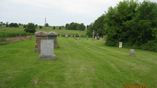
ST. LUKE'S CEMETERY
This cemetery is located on the 7th Line of Mulmur on land donated by John and Mary Little. It was given on September 11, 1849, to John Strachan, Lord Bishop of Toronto, 11to be used by the United Church of England and Ireland (Anglican). A church was to be erected and the adjoining land used for a burial ground.
In 1846-47, a log church was built and in 1860 a stone building replaced the log structure.
This cemetery is the oldest in Mulmur township and was used for all the earliest settlers, regardless of denomination.
The earliest gravestone inscription to be found is 1849 and there were many in the 1850's It is possible that there were earlier burials in the late 1830's and early 40's before the land was given to the Diocese of Toronto. It was still used for burials in the 1950's and maintained by the church.
A survey done in 1957 states that the cemetery was established in 1851 but that there was no registry of plot owners, no locations recorded, no plan, no set of rules and the grass was not cut. It was fenced and the church did have a cemetery fund. In 1959, records state it was “sprayed and cleaned up.”
The year 1962 saw procedures begin to "close down" the cemetery. 1965 saw a clean-up of the underbrush.
A government grant was accepted in September 1969 and the cemetery was deeded to the Township of Mulmur, who are the current caretakers and maintain the grass etc.
Stanton
Since 1828
Second oldest settlement; first school in Mulmur. Earliest settlers were the Hand and Walker families, who settled on the 4 corner farms.
By 1870, site of a post office, stores, 2 hotels, division courthouse and, 3 blacksmiths.
The Village of Stanton on the 6th Line (now Airport Road) and the 5th Sideroad was the 2nd settlement in Mulmur after Mulmur Corners and not too distant. When the need for a name arose the Walker and Hand families were quick to suggest "Walkerville" and Handville". A wise Judge decided that choosing one over the other would cause friction and so declared, it Stanton and so it remains
The Walkers and Hands were followed by Matthew Cauthers, 1831 and John Little, 1838. The Hands acquired 400 acres on the east side, Lots 5 & 6. The Walkers the same on the west side. In 1832, Walker sold land to Hand and buildings were built on the northwest Corner.
Mr. William Beatty built his hotel on the southwest corner in 1866. This was later sold to J. Walker, a merchant, who built his family a home.
In 1867 the post office was opened with Mr. David Gemlo, the owner of the Boyne Mill, as its Post Mas. He was followed by John A. Love, a store owner and John Ferris until it closed in 1914.
Andrew Cauthers was one of the blacksmiths, Thomas Clothley the other. John A. Love, the merchant had a store and home on the southeast Corner and this house still stands. Joseph Dixon a flour mill owner, Edward Pearson a woodworking and carriage business and Edward Beaton all moved to the village.
When fire destroyed the Court House at Mulmur Corners in 1870 a new one was built at Stanton. The 3rd Division Court was served by Bailiff Archibald Colquhoun, Andrew Cauthers, J. Armstrong and his son John. Mr. Love and Mr. John Ferris served until 1929 when the court closed and moved to Shelburne. The building was sold in 1931.
S.S. # 1, Stanton was built in 1852 on the 5th sideroad on the Creary farm. It was a log building 40' X 30' with 2 windows, one on the east side and one on the west. Two large benches with no backs faced the desks which were attached to the walls. The stove and the teacher's desk occupied the middle of the room. Pupils could tum to face their desks or the middle of the room. Water was carried by the pupils Tom Beattie's hotel. There had been two previous log schools. One was on the 5th sideroad west of Ed Bates and the ·other on lot # 3, 6th line.
Mr. Creary's sturdy stone house on the corner of the 7th line and the 5th sideroad was a place of refuge for the women and children of the district during the Fenian raids. Mattresses were used to protect the windows. It is still a landmark in the area today.
Other respected pioneers of the area were Matthew Cauthen, William Campaign, and son George, Mr. Hawkins, Robert Irwin, the Cottons, Richard and John, Clyde Newton, Reg & Erle Greer, William Mitchell Robert and Gordon Walker.
The Mulmur church served as the religious and social life of the Stanton residents. Thomas Hand served the area as Reeve in 1860 and 70, was instrumental in building the church and school." Mr. & Mrs. George Rutledge arrived about 1850 and also assisted in the plans for the construction and gave room and board to student and Junior ministers.
Descendants of these pioneer families have continued to make their homes in the township, and many can be found on the original family farm.
Terra Nova
Since 1860
Early settlers were Thompson, Duffin and Lloyd. A Methodist church and general store were built in 1889 and a post office opened in 1891. Important for shingle and saw mills.
Terra Nova, meaning New Land, was one of the last Post Offices in the township and may have been given its name then. Records do not provide that information for the community located at the junction of the 20th Sideroad and the 2nd. Line east, in the basin of the Pine River.
It is felt that Lewis Horning, Homing's Mills, John Little, Stanton and the Whitleys from Whitefield were familiar with the area but did not settle here. William Fewster from Melancthon visited the area to obtain choice pine for building.
Robert Duffin from County Down, Ireland found his way to Hamilton and then because of the infestation of vermin decided to move farther north. Unlike the Yorkshire mm who migrated to Honeywood area, he chose the sunny slopes of the land near Terra Nova and the fine lumber that abounded.
Log homes were built and the great need for shingles arose. John Abd of Lot 17 the 4th line opened a shingle mill and Welsh's sawmill came later. The dam on the Pine River for power was built by the mm labouring with shovels. The Hughstons, Ned Bradley and Ned Hicks joined the growing community in the shingle business around the year 187S. The Scriver's Mill was built on Lot 20 west of the village. These mm were followed by John Larkin, Mr. Button, Andrew Finley, John Beatty, John Ireland and the Stevenson family who were associated with the Abd Mill and when many of them began to shut down Peter Thomson operated the mills for some years.
He continued to expand, and businesses are still operating in the Thomson family in Alliston and Creemore.
The Post Office opened in 1891 in a small store kept by John Walker. He was followed in the job by John Beatty who along with the store ran a hotel at Terra Nova. Others who followed were Ben Beatty, W.T. Dean, James Simpson and Mrs. Annie Simpson.
Some of the other pioneers of the area were William Simpson who died at age 104, Robert Duffin and his brother Neilly, John Thompson and his brother Nathaniel. It is interesting to note that the Duffin family is still prominent in the Terra Nova area with direct descendants into the fifth generation.
Violet Hill
Since 1836
Earliest settlers: Bowers, Swansey Campbell, Newton, Aberdeen.
By the 1870's a thriving community with tavern, Temperance lodge, church, school, sawmill, blacksmith and an Orange hall.
Violet Hill is located on Highway # 89 near the 3rd lines of Mulmur and Mono. The name appears to have originated with Mrs. Robinson, the Post Mistress, in 1897, in whose home the office was located on the 4th line of Mulmur. She named it Violet Hill because of the vegetation on the surrounding hills.
Soon after the post office was moved to the home of Samuel Parson, then to Herb Dickeys, later to William Allen' and lastly to the east of the village to the home of Mr. John Thompson.
These men had to carry the mail from either Rosemont or Shelburne.
The village prospered. John and David Hawkins operated a sawmill and Samuel Bowers, a blacksmith shop. The community boasted of “Old Mr. Grashy' who was a dentist as well as a well digger. Mr. Richard Holt ran a shingle mill and there was a hotel known as "the Blue jay'.
Early residents included the Pages, Dickson’s, Andersons, Reid’s and Barbers. One of the log homes built by the Andersons still stands today to the east of the village.
James Swansey, Alex Mitchell, John Newton, James Halbert, James Aberdeen, John Liddy, the Robinsons, the Boggs, the Dudgeons, and the Bowers moved to the area between 1836 and 1865.
Violet Hill had a Men's temperance organization known as "The Good Templars". This group erected a log building on the Aberdeen farm for meetings. Members included Wilsons, Braiden’s, Hares, Halbert’s, Boggs and Martins.
'The Chosen Friends" was a society for both men and women for the purpose of insurance, who met also in the Templar Hall. 'The Grangers” were formed and met in a log building on the Parson farm. This was a type of co-op with members taking turns bringing supplies from the station.
Violet Hill also was proud of its Library. It was well equipped, and membership was 2S cents. The books were housed in the Templar Hall.
In 1898, the Orange Hall was built and still stands today as a commercial store.
In 1872, the Methodist Church was built on the Nicholas Parson
farm at the western edge of the village at the top of the hill. The land was given free as long at the building gained a religious meeting place. Prior to the building of the church, services were held in the Panoh home.
A school was erected in 1887, S. S. # 2, Violet Hill, just off the highway. Previously the students had to walk to the 4th line and the 30th sideroad in Mono.
The Mulmur Church was on the 2nd lot on the 5th·Line, on the Robinson farm. In 187S a building replaced the log one. A cemetery developed on the church grounds, and it is reported that Grandfather Robinson was the first to be buried there in
1854 Over the years the cemetery suffered neglect and in 1937 a committee was formed to clear the grounds, repair the stones and a stone gateway was built. The church was finally taken down and materials used from it to build a small storage shed. This committee was supported by Cliff Hand, Robert Liddy, and Alonzo Parson and the Violet Hill Women's Institute. An endowment fund provides perpetual care for the cemetery now.
Long time descendants are still on the Cotton, Newton and Parson farms.
The community continues to be home to many inhabitants today with a busy restaurant, store and gas station.
Whitfield
Once known as Beechnut Corners. Major settlement on Hurontario St.
By 1880: 3 stores, 2 sawmills, blacksmith shop, lime kiln, school, 3 churches, post office, & 2 taverns. Some descendants of the original families still farm in this area.
This community at the junction of the 10th sideroad and Centre line (Hurontario Street) was once called Beech Nut Corners.
When Lavender was settled the road became an access from south to north.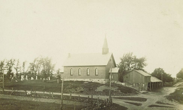
Later it derived its name from a family of "bush squatters" who occupied Lot 11 on the 10th sideroad named Whitley. Plans for the community were laid out in the 1820's by Hugh Campbell and James Whitley.
One of the earliest settlers, Edward McCabe, was granted a crown deed for the east 1/2 of lot # 4 OD the 1st concession west of Hurontario Street in January 1824. This grant reserved the rights to all the white pine, gold and silver. It is still in the possession, of the Murphy family. Water was a necessity and so a log house was built near the creek and later there followed a log barn. The settlement grew with the coming of the Murphy’s, Hutchinson’s, Mitchell’s, Cunningham’s, McDonalds, Kings, Lloyds, Huggins, Bartley’s, Wrights, Isaacs, Deans, McDowells and Watsons.
Mr. G. B. Richardson built and operated a saw on the east side.
The McCutcheon two-story house was built around 1858, believed to be the first two-story home.
John Dean and his wife Lizzie were committed Christians and moved to the area in 1860. He refused to serve whiskey to the labourers at his barn raising and they all went home. They later returned when his beliefs were explained, and the Deans made up the lack of spirits with food and entertainment.
By 1862, Robert and Marie Reaburn moved to Lot# 8, Centre Road. On their farm a lodge room was built in 1884 and the warrant still exists for Whitefield LO.L. # 366. They arranged for a minister to come to the village from Brampton to preach to the neighbors.
Mr. Shepherd Sr. moved &om Horning's Mills in 1865. He built a large stone house on the hill. Later he built a darn, a flour mill and three more houses for his workers. Business increased and he enlarged the mill. This dam washed away in 1943.
Another mill was operated by Mr. Anderson farther up the river and his power came from Castle’s Falls.
In 1871 William Thomas Mews moved from Masonville with his wife Anne Jane Clarke. They bought land just north of the Anglican Church and built 'Tom Mews Blacksmith Shop”. He ironed off many of the wagons made by Dorsey. Mrs. Mews was the midwife for the Whitfield area. Later she received help from Mrs. Johnny Bailey. The Mews home was a stopping place for many visitors as it contained the Post Office, first opened in 1854 and the only telephones. One was connected to Dr. Barr in Shelburne and one to Dr. Moore in Homing's Mills.
There were two other blacksmiths in the area: Mr. George Boyle and Mr. Johnny Bailey.
The Murphy’s built a brick home for their nine children in 1884. Whitfield’s population grew to over 100. By 1884 James Hutchinson opened a jewellery and fancy goods store. Mr. William Noble had a tavern. Mr. Fox ran a new blacksmith shop, Mr. Greenwood opened a new sawmill, but they still needed a dressmaker, and a barber.
The community now three churches and a school as well as the Orange Lodge. The Whitfield Church is active still during the summer months and for special occasions.
Many of the current Whitfield area residents trace their roots back four and five generations to the earliest of the settlers.